Satellites show that strictly protected marine areas exclude industrial fishing
Illegal fishing is a global problem that threatens the health of ocean ecosystems and the very economic viability of the fishing industry. Marine protected areas — zones set aside to safeguard marine life — are a key tool for conservation, but monitoring them has been a long-standing challenge.
A team including UC Santa Barbara researchers showed that artificial intelligence methods applied to satellite data provide a powerful new way to assess industrial fishing activity in marine protected areas (MPAs). The approach can bridge blind spots in current monitoring methods. The first-of-its-kind study, published in the journal Science, found that the world’s most strongly protected MPAs had little-to-no industrial fishing activity.
“There's a commonly held assumption that many MPAs are just ‘paper parks,’ with boundaries that exist on paper, but where fishing persists,” said co-author Gavin McDonald, a senior project scientist at UCSB’s Environmental Markets Lab (emLab). “However, we've found that for fully and highly protected MPAs, this is not the case.”
“We found that MPAs with strict legal fishing bans work better than critics claim,” said lead author Jennifer Raynor, a professor of natural resource economics at the University of Wisconsin–Madison. “MPAs can help to regenerate fish populations, which creates strong incentives for illegal fishing — and yet, that activity was mostly absent. This is good news for marine conservation.”
Strongly protected MPAs had significantly less fishing activity than surrounding waters, averaging nine times fewer fishing vessels per square kilometer than unprotected coastal areas. In addition, 25% of MPAs had no fishing vessels present from 2017 to 2021.
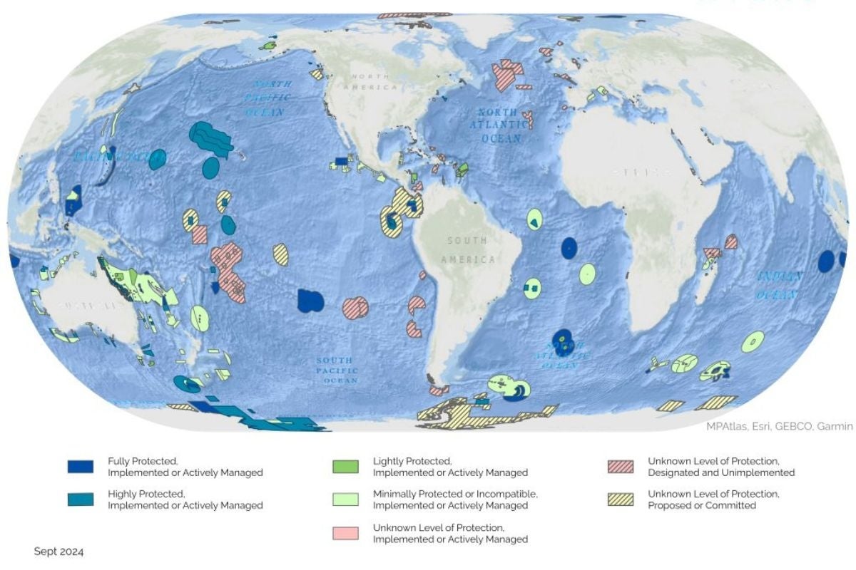
Raynor and her colleagues at UCSB, National Geographic Pristine Seas and The Nature Conservancy analyzed 1,380 marine protected areas that ban industrial fishing. Located within the world’s exclusive economic zones, or waters under the jurisdiction of coastal nations, they comprise 2.1% of the global ocean by area, including Australia’s Great Barrier Reef and Hawaii’s Papahānaumokuākea Marine National Monument.
First, the researchers examined 5 billion real-time vessel locations from the Automatic Identification System (AIS), which broadcasts vessel identity, position, course and speed to shore-based receivers to support marine safety. The AIS analysis showed little apparent fishing effort during the five-year study period. However, not all vessels are required to use the system, and captains can disable transponders or tamper with location broadcasts to evade detection. In addition, AIS is unreliable in areas with poor signal reception, such as parts of Southeast Asia.
To track the “dark vessels” that are absent from AIS data, the researchers used images created by satellites that send radar pulses to the ocean surface and measure the reflected signals (SAR, or synthetic aperture radar). A previous study showed that analyzing these reflectance patterns with AI methods reliably identified fishing vessels more than 15 meters long.
The new analysis detected just one vessel per 20,000 square kilometers (7,722 square miles), on average, in 455 MPAs with the highest imaging frequency during the study period, corroborating the results from the Automatic Identification System. Expanding the sample to 638 MPAs with at least one satellite image increased the proportion with no vessel detections from 25% to 42%. This strengthened the argument that little-to-no industrial fishing activity occurred in MPAs that ban this activity.
Importantly, the AIS data missed almost 90% of SAR-based fishing vessel detections. This was compelling evidence that relying on AIS-based monitoring alone is problematic, especially in areas with low adoption rates, frequent tampering or poor signal reception. Resource-limited nations can collaborate with nonprofit organizations like Global Fishing Watch to enhance their ocean monitoring efforts with satellite-based tools, Raynor explained.
“I was actually quite surprised, and incredibly encouraged, to find that little industrial fishing happens inside these MPAs,” McDonald said, adding that he was most surprised that this held true even for dark vessels.

Gavin McDonald’s research focuses on using data to better understand and address global environmental and social challenges, particularly surrounding global fisheries. After beginning his career as a mechanical engineer, he decided to go back to school to follow his lifelong...
By helping the ocean recover from fishing pressure, MPAs boost biodiversity inside their boundaries. But they also provide spillover benefits. “Because strictly protected marine areas discourage illegal fishing, fishes are far more abundant within their boundaries, they produce many more babies, and help replenish surrounding areas,” said Enric Sala, a marine ecologist and founder of Pristine Seas, which funded the study. “In other words, the fishing industry benefits from following the rules.”
Previous research showed, for example, that the fishing restrictions in the no-take Papaānaumokuākea Marine National Monument increased catch rates of yellowfin and bigeye tuna around it.
While the findings suggest that industrial vessels are largely absent from MPAs, they don’t explain why. “Further research is required to disentangle whether MPAs are effectively excluding industrial fishing vessels or if they were designated in low-demand areas where industrial fishing vessels aren’t present,” said co-author Sara Orofino, an ocean scientist at The Nature Conservancy. This distinction has important implications for conservation.
McDonald and his colleagues at emLab are coming up with other ways to use satellite-based data sources to help fill in the picture of environmental challenges and their solutions. For instance, they're already working with Global Fishing Watch to measure greenhouse gas emissions from marine vessels using AIS and SAR, providing a comprehensive picture of near-real-time emissions at sea for the first time.
For her part, Raynor hopes the new findings will help shape global policies for future MPAs. “By using satellites to track fishing vessels, countries can predict the locations of illegal activities and target patrol efforts, saving both manpower and money,” she said. “This is critical for reaching the Global Biodiversity Framework’s 30 by 30 target, which aims to protect 30% of oceans by 2030.”
Silke Schmidt at the University of Wisconsin-Madison contributed to this story.
Share this article
Related Stories